India finds itself a watershed moment with its urban evolution. With the United Nations projecting urbanization to reach 68% by 2050, the country's metropolitan regions needs to adapt to increasing populations while maintaining equity and quality of life. India's urban population is expected to exceed 600 million by 2030, drawing attention to both urban density and sprawl. As an emerging player in the domain of high-rise development, India is restructuring how it engages with urban growth by shifting from horizontal sprawl to vertical expansion.
With millions of residents flocking to metropolitans each year, South Asia is witnessing staggering levels of urban development. Growth brings economic prosperity and ecological strain as concrete jungles replace natural habitats. The region, home to countries such as India, Pakistan, Bangladesh, Sri Lanka, Bhutan, the Maldives, and Nepal, is faced with addressing contextual challenges when it comes to balancing urbanization with environmental sustainability. These negotiations are fairly nuanced, with a need to understand the economic, social, and political scenarios systematically in each country.
There are three primary settings in which lower-density urbanism can be useful, and where conditions favored by YIMBYs are weak or nonexistent: as a replacement for what is currently slated to be built out as sprawl, as a recovery process for existing sprawl, and in small towns that are growing. Giving up on these settings forces all development intended to combat the housing crisis into urban settings, ideally near transit, where land is much more expensive to acquire and to develop. It also allows the sprawl machine to roll on unimpeded.The best vehicle for implementing principles illustrated here at the scale of a neighborhood, hamlet, or village is not a major production builder, as these principles violate almost all of their conventional industrial practices. Instead, look to the record of stronger New Urbanist developers who are no strangers to doing things considered unconventional by the Industrial Development Complex in the interest of better places with stronger lifetime returns.
African cities are expected to experience a significant increase in population over the next 30 years. According to United Nations projections, these cities will welcome an additional 900 million inhabitants by 2050. This demographic shift will create both opportunities and challenges that will reshape the nature and structure of these cities. These challenges include the need for economic growth, increased demand for housing and infrastructure, and the development of supplementary transportation systems. So far, most African cities have responded to this rapid population growth with sprawling horizontal development patterns that expand the fringes of the city, increase social fragmentation, and ultimately lead to greater car dependency.
As of today, over 50% of the world’s population lives in urban areas, and by 2050, this urban population will almost double in size, and 7 of 10 people in the world will live in cities. As cities have continued to grow and expand throughout history, a new vocabulary has also emerged, often to better communicate the scale of urban living in a relatively contemporary context. One such example is the term megalopolis – typically defined as a network of large cities that have been interconnected with surrounding metropolitan areas by infrastructure or transportation. In effect, it’s a region perceived as an encompassing urban area, within which there is a constant flow of commerce and migration.
How we plan our cities, suburbs, and rural communities is a constantly evolving set of goals essential for creating sustainable cities. Not only do we need to consider what lies within these areas, but we also need to effectively design the boundaries between each, where urban meets suburban, and where suburban meets the small town. In recent years, urbanists have paid close attention to urban sprawl, or what sometimes happens when towns rapidly grow outwardly from city centers. What happens when cities seem to “sprawl” out of control, and are the design principals behind New Urbanism able to turn urban sprawl into equitable communities?
Beneath the Spaceship Earth geodesic sphere and the display of world cultures that symbolize Disney World’s EPCOT lies the buried vision for a utopian city. The original EPCOT - a community built around innovation - was one of Walt Disney’s last visionary projects. Bothered by haphazard urban sprawl, Disney had bold ideas for an urban fabric that would drive progress in the USA. The “Experimental Prototype Community of Tomorrow” was Walt Disney’s antidote to the decay of American cities.
Dublin Bridge Park in Columbus, Ohio. Image via Dublin Bridge Park
Suburbs as we know them are changing forever. Partially exacerbated by the effects of the pandemic, residents are leaving cities in droves in search of more favorable living conditions where more space, privacy, and affordability offers what some consider to be a more comfortable lifestyle. But as time goes on, and development sprawls, it’s harder to tell where cities end and suburbs begin.
Suburban expansion into remnant habitat / La Citta Vita, via Flickr, licensed under CC BY-SA 2.0
The export of American culture is one of the most influential forces in our interconnected world. From Dakar to Delhi, American pop music, movies, and artery-clogging cuisine are ubiquitous. However, one of the most damaging exports is the American suburb. When the 20th century model for housing the swelling populations of Long Island and Los Angeles translates to 21st century Kinshasa and Kuala Lumpur, the American way of life may very well be our downfall.
https://www.archdaily.com/943939/suburban-sprawl-increases-the-risk-of-future-pandemicsMichael Grove
I attended graduate school, in geography, in Tucson, Arizona, in the late 1990s. Tucson draws fame from a number of things, including its Mexican-American heritage, its chimichangas, its sky islands, and its abundant population of saguaro cacti.
Plenty of things about Tucson, though, are perfectly, achingly ordinary.
Perhaps the most ordinary thing about Tucson led me to develop something halfway between a hobby and an academic pursuit. On occasion, whether for sport or research, friends and I used to go “sprawl-watching.” We were not exactly, say, Walter Benjamin strolling through the arcades, embracing the human pageantry of Paris. But we did our best to plumb Tucson’s depths.
They also used this data to find a number of correlations between sprawl and poor quality of life, finding that people living in sprawling cities have higher living costs, shorter life expectancies, increased risk of obesity and diabetes, and lower economic mobility than those in dense cities.
Read on after the break to see the list of the 10 most dense and 10 most sprawling US cities
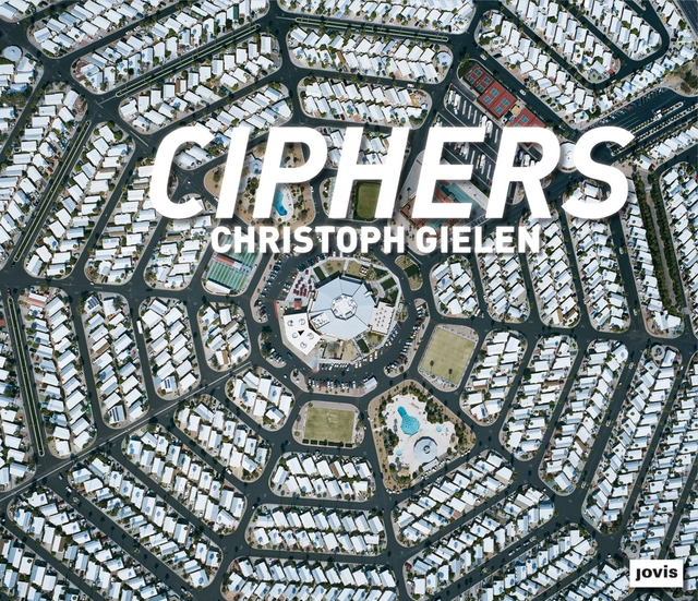
From the Publisher. Christoph Gielen’s aerial views offer a look at America’s most aberrant and unusual sprawl forms in ways we usually don’t get to see them: from far above the ground—a vantage point that reveals both the intricate geometry as well as the idiosyncratic allure of these developments. Here, encountering sprawl becomes an aesthetic experience that at the same time leaves us with a sense of foreboding, of seeing the “writing on the wall”. At once fascinating and profoundly unsettling, these photographs detail the potential ramifications of unchecked urbanization. When these settlements were developed, neither distance from work place nor gasoline prices much mattered in determining the locations of new constructions. These places are relics from an era that was entirely defined by a belief in unlimited growth, of bigger is better. The startling extent of those practices, and their inherent wastefulness, come to light in Gielen’s pictures—as if looking at a microcosm of non-sustainability through a giant magnifier.
Contributing essays by Johann Frederik Hartle, Galina Tachieva, Srdjan Jovanic Weiss, Susannah Sayler and Edward Morris contextualize Gielen’s work by focusing on a range of aspects, from aesthetics to climate change and futurology. They also examine why taking a closer look at these places is particularly crucial at this juncture, when we are faced with a new wave of building booms in developing nations such as in China.
What would the world’s landscape look like if it were concentrated into one megalopolis? This graphic analysis illustrates the amount of land required to accommodate all 6.9 billion people based on the densities of cities across the globe. The differences illuminate the adverse affects of suburban sprawl.


 license.")