MVRDV and The Why Factory's have collaborated on an exhibition that explores the principles of "architecture and urbanism calls to action”. Titled "Agir", the exhibition is open to the public since June 9th, in the connected spaces of the ArchiLib Gallery and MVRDV’s Paris office. The exhibition takes its name from the French verb meaning “act”, and examines the activist works of MVRDV and The Why Factory, revealing its capacity to address a wide variety of environmental and social challenges.
Social responsibility and the desire to improve society has long been influenced by the built environment. Looking at city centers, architecture has contributed to the improvement of the urban fabric, whether it being through planning and zoning strategies, integration of public spaces, or small interventions. In some cases however, these interventions are in fact used as tools to keep the homeless off the streets, disguised as art or conceptual designs. Several public urban policies have all implicitly prohibited the homeless and other marginalized social groups from city centers, claiming that their presence and “irregular” use of public space could compromise the reputation, security, and desirability of the city.
An online search away from any computer are eye-level views of many of the world’s cities. This technology is powerful – allowing people to have an in-depth look at the cities they might one day visit, live in, or work in. It’s a useful tool for understanding buildings on a more comprehensive level than photographs. This technology is, of course, Google Street View – which recently turned fifteen years old.
To wholly document a survey on the state of French forests, the wood industry, and forestry R&D, François Leclercq and Paul Laigle, from the architecture and urban planning practice Leclercq Associés, are in collaboration with architecture editor Michèle Leloup and photographer Cyrille Weiner.
The Wood That Makes Our Cities explores the environmental, economic, industrial, and technical challenges involved in the use of wood for large structures and urban architecture and assesses the future of wood construction. The book retraces the practice’s twenty years of experience with wood construction through five of its projects, featuring contributions by historians, researchers, manufacturers, timber producers, and forestry specialists.
Architecture, with all its practitioners, academics, and theorists, have long been exploring utopic ideas with hopes of turning them into something concrete for the sake of a better world. But as the world heads towards an even greater polarization than it currently has, the architecture practice found itself having to adapt to the current systems of the planet, constrained by its ever-growing conditions. Slowly, practitioners realized that utopia can not truly be seen as the ideal solution, and needed to be readapted or morphed with other concepts for it to actually work. DETAIL's latest monograph BIG. Architecture and Construction Details / BIG. Architektur und Baudetails, a rapport between BIG’s imaginative, unbuilt utopias and functional, built architecture, explores 20 projects from the firm's workshop.
We are still at the dawn of the Metaverse, the next wave of the Internet. The current “mainstream” Metaverse platforms serve as experimental containers to host the wildest dreams of virtual worlds where we are supposed to unleash the imagination. However, from a spatial design perspective, they have so far been lame and ordinary. Without the constraints in the physical world, how do we draft the urban blueprints in the metaverse? I believe metaverse planners can find inspiration from Italo Calvino’s Invisible Cities, in which he revealed a poetic and mathematical approach to “urban planning” in the imaginary worlds.
Sundance Square, a new central place for the city of Fort Worth, TX, USA. Image Courtesy of PPS
Public spaces play a significant role in organizing the life of every community but defining what differentiates them from other spaces within the city is not an easy task. Once these spaces start to settle into the collective memory of the local communities, they become key elements that concentrate the mental image of a city. While this process usually happens with urban spaces, monuments and isolated architectural elements can also become markers for the urban life of an area. So, what happens when dramatic events like fires, war, or even the pandemic alter that image?
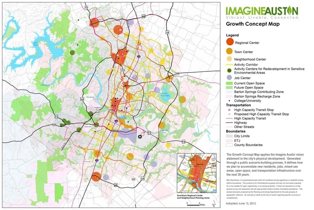
Imagine Austin Growth Concept Map / City of Austin. Image Courtesy of The Dirt
“The planning practices of the past are inadequate for today’s challenges,” said David Rouse, ASLA, a landscape architect and planner, at the American Planning Association‘s National Planning Conference in San Diego. Rapid technological change, socio-economic inequities, natural resource depletion, and climate change are forcing planning and design professionals to adapt. “How can the practice of planning evolve to be more sustainable and equitable?”
https://www.archdaily.com/982475/planners-must-now-anticipate-the-unanticipatedJared Green
The topic of cannabis can be rather taboo in some instances, as countries around the world have differing views on the legalization of marijuana products based on their cultural and religious beliefs. In the United States specifically, it’s been a long contended issue that each state has, for now, been left to decide on how they want to handle. Each year, more and more states (now totaling 18 and the District of Columbia out of 50), have legalized the recreational sale and use of a limited amount of cannabis, but it remains illegal on a federal level.
The new, online NYC Climate Dashboard confirms that New York City is not doing enough to meet its climate goals. What’s worse, the goals don’t measure up to the challenge citizens face. A growing consensus among scientists says the world has only until the end of this decade to avert catastrophic climate change. Here in New York, the biggest contributions to greenhouse gasses come from our buildings and our driving. As an architect and urban designer, John Massengale shares what he believes the world is missing and some significant changes that the world can make for the sake of future generations.
Neighborhood Next / 15 Minute City by Gehl Architects. Image Courtesy of 3XN
The planning and design of mixed-use neighborhoods and individual mixed-use developments are on the rise. Many of the places we frequent most feature a variety of programs, bringing many of life's daily conveniences to one place. But mixed-use spaces do more than just create a diverse array of experiences in cities- they might also help contribute to lower crime rates.
There’s something magical about seeing a city from the very top. To have a new vantage point, and look across a skyline instead of looking up at it is one of the most powerful and awe-inspiring feelings. Observation decks are not just architectural marvels, but also a sort of civic icon and sense of pride for a city. In the present day, it’s not just their height that draws people in, but the additional programming of sky-high bars, rides, and bungee jumping as well.
Almost seven kilometers from the green of Uhuru Park in central Nairobi, lies the informal settlement of Kibera. It is an area whose urban character consists of corrugated iron roofs, mud walls, and a complicated network of utility poles. Kibera, at this point in time, is a well-known place. Much has been written and researched on this “city within a city,” from its infrastructural issues to its navigation of the COVID-19 pandemic.
Can a piece of infrastructure literally kill a city? This is the question that writer Jim Krueger poses in his recent podcast, The Road That Killed a City. The place in question is Krueger’s current hometown—Hartford, Connecticut—which he grew up next to in the leafy suburb of West Hartford. Kruerger has lived in both towns, and that helps to balance the amazing story he uncovers about how Connecticut’s capital was impaled by a roadway (actually, two: east/west I-84 and north/south I-91 converge in Hartford in a sort of arterial highway ground zero). I spoke with Krueger about what prompted the podcast, some of what he uncovered about the history of this ill-fated urban “improvement,” and the legacy of a highway that continues to thwart Hartford’s rebirth—an inheritance shared by many cities across North America.
https://www.archdaily.com/981425/did-a-highway-kill-the-city-of-hartfordMichael J. Crosbie
In New Mexico, irrigation channels that have been in continuous operation for three centuries replenish and nourish the wetlands of the American Southwest. These channels are known as Acequias – communally managed water systems built on democratic tradition. Members of the community own water rights, who then elect a three-person team to oversee the channels. In Cairo and Barcelona, Tahrir Square and Plaza de Catalunya have acted as important sites for voicing political dissatisfaction. The Tahrir Square protests of 2011, for instance, resulted in the eventual toppling of an almost 30-year-old government.
The climate crisis has accentuated changes in the amount of rainfall, causing droughts or storms with large volumes of water, which result in floods that can cause great damage to urban infrastructure. To combat this, the sponge city is a solution that has a green infrastructure to operate the infiltration, absorption, storage and even purification of these surface waters.
Over the past two decades, urban highways' social and economic ramifications have been brought into focus as a large part of this mid-century infrastructure comes to the end of its lifespan, prompting conversations over its role in contemporary urban planning. Freeway removal entails the replacement of the transport infrastructure with new urban developments, green amenities and alternative street grids to promote a healthier urban environment and smart growth. In some cases, the idea of removing highways is met with concern over the potential increase in traffic and gentrification of the areas adjacent to the road, but the pandemic has further exacerbated the need for quality public spaces and brought once again into question the hegemony of the car. The following highlights various highway removal projects, discussing how these interventions restore the urban fabric, reknit communities and recover urban spaces for city dwellers.
15-minute cities are a trending urban planning topic that has long been discussed academically and is now slowly being implemented across existing cities in Europe. But now, the first 15-minute city is being designed and built from scratch in Utah. Dubbed “The Point”, the new 600-acre city will be located just outside Salt Lake City, and will be a redeveloped former state prison site where new jobs, housing, public spaces, amenities, and transportation will serve almost 15,000 people in an attempt to explore a prototype for how innovative urban planning concepts can improve the public health and wellness.

.jpg?1655725729 "© Juan Jerez")

.jpg?1655725498 "© Juan Jerez")


._Image_by_Zupagrafika.jpg?1653259487 "Orła Białego prefab panel estate in Poznań (Brutal Poland). . Image © Zupagrafika")


.jpg?1653161266&format=webp&width=640&height=580)


_Credit_Santiago_Calatrava.jpg?1652412911&format=webp&width=640&height=580)


.jpg?1651830269 "Khayelitsha Township - Cape Town. Image © Olga Ernst under the Creative Commons Attribution-Share Alike 4.0 International license.")


