Now in its 18th edition, the Sony World Photography Awards serve as a global platform for both established and emerging artists, offering an annual glimpse into contemporary photography. This free-to-enter competition provides exposure across 10 categories, including Architecture, Landscape, Travel, and Street Photography. Each category awards a winner, features a shortlist of selected works, and culminates in the title of Open Photographer of the Year. For the 2025 Open competition, participants were invited to submit their strongest single images from 2024, with a focus on capturing and distilling a singular moment while evoking a broader narrative.
The heritage of Mexico City is extremely rich and diverse due to a long history that overlays like layers above the urban fabric since pre-Hispanic times. Currently, it is one of the largest cities in the world, and its heritage is reflected in its architecture, museums, historical sites, cultural traditions, protected sites, gastronomy, and much more. This chronology has been evidenced through various historical records. However, contemporary recording is essential in moments where we are writing history immediately with different digital tools.
In the summer of 2022, Iwan Baan completed an urban pilgrimage through the unique streets of Prague. For 7 days, the photographer photographed the city on foot, on a bike, and from a helicopter, capturing the essence of the urban fabric, from the center to the periphery and the landscape along the Vltava River. Presenting the city as a raw and often neglected entity, Iwan Baan showcased his exhibition “Iwan Baan: Prague Diary” this year at CAMP.
Las Palmas, Canary Islands. Drone photo by @sebastien.nagy
Fascinating and photogenic, colorful cities often catch the eye not only of the thousands of tourists visiting every year but also of many architects around the world. From an aerial viewpoint - which happens to be how many visitors get their first glimpse of these cities from the window of an airplane - one can see the colorful picture created by the many different shades of roofs and rooftops.
There are many different reasons for this diversity of colors. Some cities use specific colors on roofing as a climate strategy, while others simply have a tradition of painting houses in a certain way. In any case, these colorful cities are unquestionably very visually appealing.
Commerce has seen many changes over the past few years, especially as people worldwide have found new ways to connect and work with one another. In spite of this rapid progress, traditional commerce and cultures remain strong in Mexico City's tianguis, derived from the Nahuatl word tianquiz(tli) for “market." These open air spaces have operated since before European invasion and colonization, when bartering was the primary means of commerce and transactions were done in large public areas like plazas and corridors. Eventually, products derived from copper and cacao became a form of currency with which to purchase basic necessities.
Capturing aerial photographs allows raising awareness of a project feature usually complex to capture using traditional methods. Based on the technological opportunities offered by small unmanned aerial vehicles (UAVs), commonly called drones, architecture photographers have begun to explore new ways of capturing a project in order to expose design decisions such as implantation, dialogue with the environment, or the relationship with nearby buildings.
Chicago, United States. Created by @overview. Source imagery: @nearmap
Because of the decrease in the availability of land area and the ever-increasing price per square meter, cities often tend to grow vertically. When we picture large metropolitan areas, we almost always imagine high-rise buildings, and the recognizable skyline becomes an icon that immediately evokes the places in which they are located.
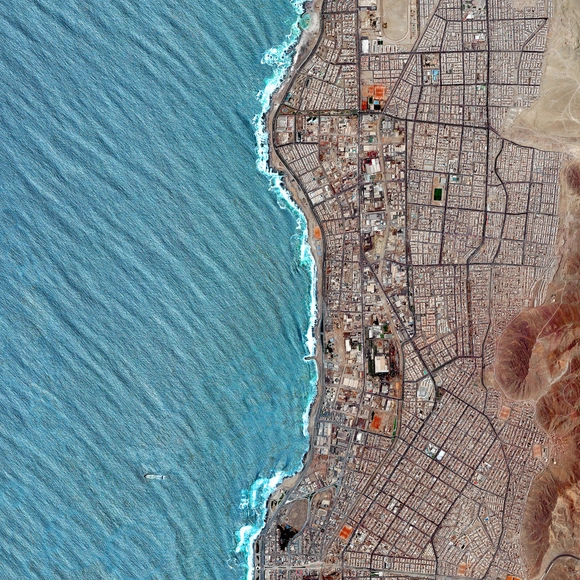
Antofagasta, Chile. Created by @overview. Source imagery: @maxartechnologies
“There seems to be a public image of any given city which is the overlap of many individual images," American urban planner Kevin Lynch once said. "Or perhaps there is a series of public images, each held by some significant number of citizens,” he added.
Following this remark, in his book "The Image of the City" (1960), Lynch begins an analysis around the elements that constitute what he considers to be the image of the city. While introducing, describing, and illustrating these elements as physical, perceptible objects, Lynch considers that other non-physical factors such as history, function, or even the name of the city also play a significant role in the construction of this imageability.
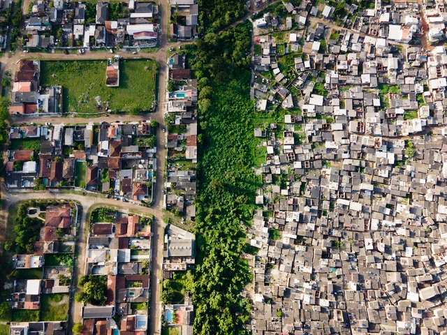
Most people are familiar with the concept of social and economic inequality, but although it affects a large part of the world's population, it is still somewhat abstract for many people. Photographer Johnny Miller intends to make it visible through his project Unequal Scenes, capturing images of spatial inequality from a very revealing perspective: aerial imagery.
The project started in South Africa, a country that is socially and spatially marked by apartheid, and now has been taken to Brazil to document scenarios in which extreme poverty and wealth coexist within a few meters, showing how distance is not only a measurement of physical length but can also imply more complex aspects, deeply rooted in our society.
A radial concentric city plan is formed by streets that extend outward from a defined center and reach the outer edge of the city, together with concentrically arranged roads that connect the radial streets to the lots. This pattern traces back to ancient times and continues even to this day.
Depending on the historical context, location, or purpose of the city planning, the element found in the center may vary. Plazas, churches, or government buildings are among the most common elements and this is no accident, nor is the urban design pattern. Basically, the radial arrangement of streets is intended to highlight a particular element or location that has great political, religious, financial, or symbolic value to the city as a whole.
Collectives, is a series of aerial imageries by Brazilian photographer and artist Cássio Campos Vasconcellos, made from articulated photos captured during helicopter flights. On-going for almost 5 years, the project consists of large-format works portraying chaotic urban landscapes and exploring “jam-packed situations typical of our civilization”. Aiming to showcase the impact of human activity on the world, the collection of images is a visual investigation of our consumer society.
Seeing from above – the aerial vantage point – is the illusion of knowledge. This was the idea of Frenchman Michel de Certeau, a historian who was interested in the everyday practices that occur on the ground, on the streetscape. In contrast to Certeau's view, satellite images can be a powerful tool to understand, predict, and strive for a better future for humankind. This is the mission of Benjamin Grant, founder of Overview, a platform that explores human activity on Earth through aerial imagery.
Interested in fostering "an experience of awe" through elevated vantage points of our world, Overview offers snapshots featuring traces of human activity on the surface of the planet. Photos of cities and other cultural artifacts join pictures of mesmerizing topography and natural beauty in an impressive archive of drone and satellite images. Awe abounds as we face not only some of the most impressive human endeavors seen from the sky, but also as we are confronted with the rather gruesome side-effects of our very existence on Earth.
Beijing Daxing International Airport / Zaha Hadid Architects. Image by @seven7panda
In architecture and urbanism, both proximity and distance from a certain object of study, whether on a building scale or urban scale, are frequent strategies that help us better visualize details and also have a broader overall perception, both essential for understanding the object in question. Changing the point of view allows different perceptions of the same place. By moving from the ground level, or from the eye-level, which we are accustomed to in everyday life, to the aerial point of view, we can establish connections similar to those achieved through site plans, location plans, and urban plans.
"Soy de Azteca" (Or "I'm from Azteca") is a photographic project by Zaickz Moz that seeks to re-think the expressions of community and identity of the periphery of Mexico City—which is becoming more diffuse and overflows beyond its geographical limits. The objective of this project is to re-think the interpretations of community and identity of the residents of Ciudad Azteca (State of Mexico) manifested in private, public and urban spaces, through photographic series that addresses issues such as appropriation and modification of space habitable, urban development and the sense of community in the neighborhood of Ciudad Azteca.
The particular characteristics of a community give the inhabitants a sense of identity and belonging. Does this happen in any inhabited place? When observing that the history of Ciudad Azteca always exists in relation to Mexico City, it is worth asking if identifying traits have emerged among the inhabitants of Ciudad Azteca. As in other areas of the capital's periphery, it is possible to observe in this group of neighborhoods located in the municipality of Ecatepec the capacity of the locals to build and transform a space into a variety of forms of urban habitat.
Exploring the streets of foreign cities is profoundly engaging. Whether it's meeting new cultures, observing new architectures, or trying new food, travelers usually go for the typical sightseeing activities. However, some have quite a unique take on tourism and choose to think outside the box - or in this case, above it.
Hungarian photographer Márton Mogyorósy chose to explore the Catalonian capital from above, capturing aerial shots of the city. Drone photography has helped us see cities from a unique perspective, and with Barcelona’s dynamic urban fabric, the coastal city’s buildings and beaches have turned into vibrant geometric artwork.
The winning entries of the Siena International Photo Awards 2018 have been unveiled. The “Architecture and Urban Spaces” category winners offer a wide range of subjects, locations, and perspectives, from the relationship between the Moon and the Leaning Tower of Pisa to snow-capped “Toy houses.”
The Siena International Photo Awards saw 48,000 images submitted from 148 countries. The announcement of the winners coincides with the launch of the “Beyond the Lens” exhibition of the winners, running until 2nd December 2018 in Siena.
https://www.archdaily.com/905130/these-international-award-winning-photographs-capture-the-beauty-of-architecture-and-urban-spacesNiall Patrick Walsh
"Sand Castles (part II)" by Markel Redondo. Image Courtesy of Markel Redondo
The winners of the DJI Drone Photography Award have been announced, a competition calling for ideas to make creative use of drone photography, and to explore subject matters impossible to experience on foot. This year, the two winning projects consisted of a new perspective on Spain’s 3.4 million abandoned houses, and the documentation of salt production across Europe.
https://www.archdaily.com/892004/beauty-or-tragedy-aerial-imagery-of-spains-abandoned-housing-estates-wins-dji-drone-photography-awardNiall Patrick Walsh


.jpg?1627416884 "© Alex González / Dronalexmx")
.jpg?1627416979 "© Alex González / Dronalexmx")


\" by Markel Redondo. Image Courtesy of Markel Redondo")
\" by Markel Redondo. Image Courtesy of Markel Redondo")
\" by Markel Redondo. Image Courtesy of Markel Redondo")
\" by Markel Redondo. Image Courtesy of Markel Redondo")

