Foster + Partners' Apple 2 Campus is racing towards its December 2016 completion date. As seen in this drone video captured by aerial videographer Matthew Roberts, the exterior of the spaceship-like main building is nearly finished, with many of the campus' other buildings, such as the auditorium, the research & development center and the 100,000 square foot corporate fitness center, also approaching full realization.
Drones: The Latest Architecture and News
Video: Apple 2 Campus Headed Toward Completion
https://www.archdaily.com/792929/video-apple-2-campus-headed-toward-completionPatrick Lynch
Soar Through a Neo-Byzantine Church in This Dramatic Drone Video
Set to a soundtrack suitable for the most climactic moment of an episode of Game of Thrones, this drone footage from filmmaking duo BigFly takes viewers inside the St. Louis Church in Paimboeuf, France. As it carefully navigates around the church’s arches and pendentives, the drone captures the space in a distinctly golden light, giving viewers up-close looks at the bold colors and flamboyant ornamentation for which the neo-Byzantine style is recognized.
https://www.archdaily.com/789893/soar-through-a-neo-byzantine-church-in-this-dramatic-drone-videoPatrick Lynch
Norman Foster Explains How Drones in Rwanda Could Lead the Way for New Cities
Back in September, Foster + Partners released details of their designs for a droneport in Rwanda, a humanitarian initiative that seeks to jumpstart and navigate the infrastructural challenges of emerging economies. In this video, Foster and others involved in the project explain the process of realizing the droneports, giving further details on its inclusion in this year’s Venice Biennale—with engaging new architectural visualizations to boot.
https://www.archdaily.com/789122/norman-foster-explains-how-drones-in-rwanda-could-lead-the-way-for-new-citiesJan Doroteo
See Aerial Footage of an Italian Riviera Abandoned During Winter

A new video by PONGOFILMS titled, “Archaeology of the Sea” captures footage of Italy's Riviera Romagnola during the winter. Using drones, the footage is captured from above, displaying closed aquatic recreation centres in "a place where it's difficult to understand what is waiting for the summer and what will remain lost." Boat rentals, cabanas and nightclubs laze into the frame, bereft of the buzz and activity that usually occupies them. See the full video, with accompanying soundtrack by Tame Impala, below.
https://www.archdaily.com/782608/see-aerial-footage-of-an-italian-riviera-abandoned-during-winterEric Oh
Drones and Rendering: How Aerial Photogrammetry Adds Existing Topography into Visualizations
Corcovado and Christ the Redeemer by Pix4D on Sketchfab
As I have touched on in the past many times, context is what transforms an artistic rendering into a photorealistic visual that accurately portrays a building. Seemingly minute details such as the warmth of interior lighting in night renders can actually make a dramatic impact on how the image is received by a potential client or investor. With this in mind, and in a continual attempt to improve the accuracy of renderings while increasing the value they provide to architects, some rendering artists are now taking advantage of readily available Unmanned Aerial Vehicle (UAV) platforms – more commonly referred to as drones – to gain a unique vantage point of land slated for development.
In the past capturing aerial photographs of an area could only be achieved from planes or helicopters, both of which come at a hefty price tag, even to rent. Drones equipped with the same capabilities can now be purchased for a fraction of the cost, making aerial photography more attainable. Aside from capturing standard video or images, drones have given rendering artists access to software that allows them to accurately map the topography of an area slated for development, adding a new level of context and accuracy to the rendering.
https://www.archdaily.com/779698/drones-and-rendering-how-aerial-photogrammetry-adds-existing-topography-into-visualizationsJonn Kutyla
This Drone Video of Los Angeles Highlights the City’s Many Murals
In this wide-ranging video, drone videographer Ian Wood captures the diversity of the built environment in Los Angeles, featuring architectural gems on equal footing with freeways and freight trains. The buildings and locations featured in the video span over a century of architectural history in LA, and cover the region’s vast geography, including such icons as Frank Lloyd Wright’s Hollyhock House, Cesar Pelli’s Pacific Design Center, Eric Owen Moss’ Stealth building, and Morphosis’ recently completed Emerson College Los Angeles.
But what truly sets this video apart is how it highlights the many murals spread throughout the city. Often utilizing otherwise blank facades facing parking lots and alleys, these murals are nonetheless an integral part of LA’s urban fabric, as illustrated in this video. Sadly though, as Wood notes on the video description, there were many more murals that vanished before he was able to get them on video.
https://www.archdaily.com/779434/this-drone-video-of-los-angeles-highlights-the-citys-many-muralsDavid Douglass-Jaimes
These Drone Photographs Reveal the Hidden Geometries of Late Soviet Modernism

Though the ahistorical dogma of modernism would seem a perfect fit for the Soviet Union’s mandated break with traditions, the architectural history of the USSR was somewhat more complex. Stalin’s neoclassically-inflected socialist realism superseded the constructivist heyday of the early Soviet Union, only to be replaced by a return to modernism under Khrushchev, facilitated by an opening to the West. Architectural photographers Denis Esakov and Dmitry Vasilenko recently used a drone to capture photographs of several landmark structures of the Khrushchev-era return to modernism, focusing on how these aerial views reinforce their rational geometries and regimented forms. Until the recent advent of satellite imagery and commercially available drones, these were views that were only ever seen by the architects, and the officials who reviewed the plans. Even so, the photographer notes that these methodical forms must have been very attractive to the state officers tasked with implementing Khrushchev’s mandated aesthetic.
The photographs, taken in and around Moscow, include works by several prominent Soviet architects. Leonid Pavlov’s long career spanned the full spectrum of state-sponsored architectural styles, starting as a constructivist, and moving into more historicist designs under Stalin, before emerging as one of the Soviet Union’s most prominent post-war modernists. Similarly, Yuri Platonov’s work received extensive state recognition, earning him the title of “People’s architect of the USSR,” as well as awards such the Silver Medal of the Arts Academy of the USSR, the USSR State Prize, and the State Prize of Russia.


https://www.archdaily.com/779042/these-drone-photographs-reveal-the-hidden-geometries-of-late-soviet-modernismDavid Douglass-Jaimes
4 Experiments in Robot and Drone 3D Printing that Could Shape Architecture's Future

In manufacturing, the dramatic recent expansion in the capabilities of 3D printing has threatened to revolutionize the way that things are made. In architecture though, while 3D printing has been received with enthusiasm its translation to the increased scale of buildings has been challenging. Most solutions to this problem have focused on increasingly large printers and the incorporation of existing principles of prefabrication - however there is another way. In this article, originally published on Autodesk’s Redshift publication as "4 Ways a Robot or Drone 3D Printer Will Change Architecture and Construction," Zach Mortice looks at four examples of cutting-edge research into 3D printing that utilize robots or drones to navigate architecture's challenging scale.
Buildings simply aren’t made like anything else—that goes for sunglasses, furniture, appliances, and fighter jets. No other production process brings massive amounts of material to one place, constructs one item, and then hauls away the garbage. The inefficiencies are monumental.
Modular construction has promised a great deal of potential to reduce waste. But what if one answer is to do more intricate construction on-site, not less? 3D printers attached to robots and drones are demonstrating that they might have the versatility to finally bring the unruly building process to heel.

https://www.archdaily.com/774549/4-experiments-in-robot-and-drone-3d-printing-that-could-shape-architectures-futureZach Mortice
These Two Drones Just Built a Bridge
View post on imgur.com Two quadcopter drones just autonomously built a footbridge that is capable of withstanding the weight of a human. Outfitted with a motorized spool and plastic tubes that dispense Dyneema, a "material with a low weight-to-strength ratio," the flying machines were able to construct a lightweight tensile bridge that spans 7.4 meters between two scaffolding structures at the Flying Machine Arena in Zurich.
https://www.archdaily.com/774224/these-two-drones-just-built-a-bridgeKarissa Rosenfield
Foster + Partners Unveils Design for Droneport in Rwanda
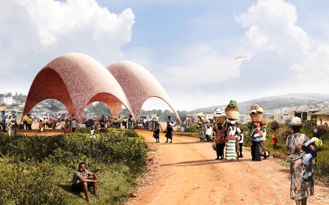
Foster + Partners has unveiled designs for a droneport in Rwanda, proposed in an attempt to bring more efficient medical care and commercial delivery services to communities in Africa where there is a lack of infrastructure required to meet the population's needs.
"Just a third of Africans live within two kilometres of an all-season road," explains the press release. "It would require unprecedented levels of investment in roads and railways to catch up with the exponential growth in Africa’s population, which is set to double to 2.2 billion by 2050." Foster + Partners instead proposes to leap that development hurdle by making use of 21st century technology - namely drones.
https://www.archdaily.com/773757/foster-plus-partners-unveils-design-for-droneport-in-rwandaRory Stott
VIDEO: Apple Campus 2 Begins to Take Shape
Overlapped with commentary by the late Steve Jobs, a new video update by drone pilot Duncan Sinfield has captured Apple Campus 2 taking shape. According to the report on MacRumors, work is still being done on the main building's multi-level underground parking structure, while the west campus parking structure is nearly complete. The auditorium now has interior walls and progress is being made on the Tantau development housing research facilities.
https://www.archdaily.com/773017/video-apple-campus-2-begins-to-take-shapeKarissa Rosenfield
12 Stunning Aerial Photos Taken with a Drone

Photographer Amos Chapple has traveled the world, capturing well-known landmarks and cities from the perspective of a drone. From the Katshi Pillar in Georgia to New Delhi’s Lotus Temple and the star fort in Bourtange, the Netherlands, Chapple carried out “as much aerial work as weather and local laws allow.”
See 12 of his most impressive photos after the break.


https://www.archdaily.com/639498/12-stunning-aerial-photos-taken-with-a-droneAD Editorial Team
The Power Of The Plan: Drones And Architectural Photography
What is the draw of the aerial view? Whereas architects and designers often find solace in this particular spatial perspective there is a more inclusive, universal appeal to this way of seeing. The ease of access to online mapping services has increased our collective reliance on understanding our world from above.
Maps condense the planet into a little world inside our pocket, the commodification of which has universalised the ‘plan-view’ photograph. The question of whether or not their ubiquitous availability, having now been assimilated into our collective consciousness, is a positive step for the status of the plan is a discussion ongoing. Yet, in the face of this dilemma, architectural photographers are pushing the boundaries of drone technology in order to find new meaning.


https://www.archdaily.com/591341/the-power-of-the-plan-drones-and-architectural-photographyJames Taylor-Foster
Video: Drone Tour Inside St. Peter's Seminary
Scotland's Grade-A listed Brutalist St. Peter's Seminary, abandoned for the past 25 years, is being rediscovered through drone technology. The building, which was originally designed by Gillespie, Kidd & Coia in 1966 and heavily inspired by the work of Le Corbusier ("with Scottish inspirations"), has recently been offered a new lease of life. London-based Avanti Architects, along with Glasgow-based ERZ Landscape Architects and NORD Architects, recently released the first images of their plans to breathe new life into the iconic building. This filmed footage not only gives a sense of how dilapidated the structure is in its current state, but also hints at the exciting possible future it has as an arts venue.
https://www.archdaily.com/590732/video-drone-tour-inside-st-peter-s-seminaryJames Taylor-Foster
Norman Foster Revisits New York's Hearst Tower With Drones
To mark the 10th anniversary of the topping out of New York City's Hearst Tower, Lord Foster returned in order to narrate a short film shedding new light on the building with the aid of camera drones. The 46 storey building - which is integrated into a 6 storey base brick structure designed by Joseph Urban in 1928 - was "one of the most sustainable buildings of its time." Now, ten years later, this footage captures spectacular new views of the main atrium.
https://www.archdaily.com/588403/norman-foster-revisits-new-york-s-hearst-tower-with-dronesJames Taylor-Foster
The Three-Dimensional City: How Drones Will Impact the Future Urban Landscape

Many have come to associate drones with the looming unmanned aircraft deployed in the defense industry, but as technology continues to improve drones have gotten smaller and progressively less expensive. Consumers can now purchase their very own drone for as little as $600 or less and the technology is already proving to be useful for a wide variety of purposes, including possible uses for architects in everything from site analysis to construction.
However, this technology could have much broader consequences on not only the airspace above our streets, but also in how we design for increasing civilian and commercial drone traffic. Just as other technologies such as cars and security surveillance have shaped our urban infrastructure, so too will an emerging network of infrastructure for pilotless technology. Particularly as drones become ever more precise and nimble, opportunities arise for their increased use in urban areas. If these devices can be programmed to learn from repeated maneuvers with the use of cameras and sensors, it is not unrealistic to say that they could soon learn how to navigate through increasingly complex vertical cities. But if drones become fixtures of our urban environment, what impact will they have on exterior spaces? And could they become as ubiquitous in our city’s skies as cars on our streets?
https://www.archdaily.com/583398/the-three-dimensional-city-how-drones-will-impact-the-future-urban-landscapeEvan Rawn
Video: The Latest Development at the 2015 Milan Expo Site Revealed with a Drone
The 2015 Milan Expo has been keeping architecture fans in the loop with "Belvedere in Città," its continuing series of videos filmed with the help of a drone. Since our update last month, two new videos have been released - and now that the recognizable forms of the pavilions are starting to emerge, the videos include labels for each feature of the expo site. With the help of these new videos it is easy to see the forms of highly-touted pavilions such as Libeskind's Vanke Pavilion, or Nemesi & Partners' smog-eating pavilion for Italy, gradually taking shape around the twin axes of the "cardo" and "decumanus," an ancient Roman planning tool borrowed for the site's masterplan by Jacques Herzog, Mark Rylander, Ricky Burdett, Stefano Boeri, and William McDonough. Read on after the break for the second video, and screenshots of the construction works.


https://www.archdaily.com/572763/video-the-latest-development-at-the-2015-milan-expo-site-revealed-with-a-droneRory Stott
Video: A Drone's-Eye View of Apple's New Campus Under Construction
At the moment it may be little more than a colossal, doughnut-shaped hole in the ground, but this video is in fact the first glimpse of Apple's new Norman Foster-designed Campus in Cupertino. The video, shot using a GoPro camera mounted on a drone, shows that construction of the building's huge underground parking garage has begun, with concrete poured in a section of the trench. And, as we've come to expect from Apple, the fact that it's a construction site is no excuse for messiness, meaning that elements of the design are already starting to be legible, such as a wider trench marking the main entrance close to the drone's position. Watch the video above to see the huge campus under construction, and read on after the break for more information about the building's design.
https://www.archdaily.com/542946/video-a-drone-s-eye-view-of-apple-s-new-campus-under-constructionRory Stott